Tag Archives: complexity

Emergent Urbanism at the University of Montreal

I was invited to the complex systems laboratory of the Université de Montréal this week to present emergent urbanism to their twenty-member large research group. Click through to SlideShare in order to see the full text of the presentation under the “notes on” tab. The entire text is in French, however I know a significant share of this website’s visitors enjoy French once in a while.


If someone wants to sponsor me for a translation in English, email me and I’ll upload one very soon. Otherwise my hands are quite full at the moment, it might be a while before I get around to it.

Thanks to Rodolphe Gonzales from the Complex Systems Lab for the invitation. You can read about their work here.

Principles published

The full article conceptualizing the principles of emergent urbanism has been published by the International Journal of Architectural Research volume 3 issue 2. You can download the complete article or read the whole issue.

Modeling the processes of urban emergence

Placelife

The growth process of an emergent city actually consists of five growth processes. These processes are hierarchically related, that is to say the morphology decided by processes at higher levels of complexity depends on decisions taken at lower levels of complexity. They are not constrained by one another, as modern planners claim when they clear slums in order to build their architectural vision, but expand upon one another, creating a landscape that is tied to a history of adaptation and transformation in order to meet the needs of the present at every point in time.

Each transformation is the decision of an individual, acting within the context he perceives and the ends that are identified. These ends may be within his own sphere of life, by expanding his home, or subdividing his property to build a home for his grown children, but more likely they are the consequences of identifying a potential created by the individual actions of others. For example, if a sufficient number of neighbors have settled, opening a bakery. In this way networks are built upon the potentials created by the last network extension, (in one such instance by capturing residual movement in the grid as Bill Hillier describes) and the city increases in complexity.

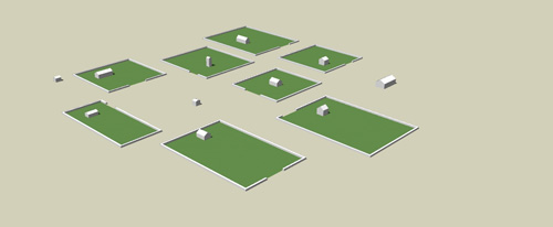
The foundation process of a city, before anyone can even imagine a city being there, I call the place. A place is nothing more than a free surface available to be settled. Newcomers build their home wherever they want in the place, and that implies that they will locate their homes to take maximum advantage of natural features, and space themselves away from their neighbors in order to avoid conflicts over the use of common lands. A place settlement process is how shantytowns are created, except that because there does not exist any functional land ownership in a shantytown there is no limit to how many buildings can be created. Thus the shantytown never reaches the second process of urban emergence, creating a crisis. A place may be created deliberately, by transforming a farm or other types of land use to that purpose, by building fortifications within which land is protected from harm, or a place may be given by nature simply by being available and strategically located.

Place

A place is an open space where people may settle and build randomly

As places become increasingly dense, the use of space by neighbors will create conflicts of proximity. Land will no longer be superabundant. In order to resolve these conflicts a process of land enclosure delimits the boundaries between neighbors’ households by negotiating the boundaries of land that is in private and common use. Streets and blocks thus appear, and those spaces where common use is particularly intensive, because of highly valuable natural features or central locations, become recognized as public squares and greens.

Enclosure

Enclosures delimit private and public spaces, and the pattern of streets, blocks and squares emerges.

With available land to settle either enclosed or occupied by public activities, it becomes more difficult for new growth to take place. New buildings built on remaining place must be justified before a community increasingly protective of the remaining open space. In most cases it is much simpler to ask one of the members of the community to give up a part of his property in order to grow the new part of the town, introducing the process of subdivision. These subdivisions are negotiated case-by-case and thus adopt random sizes and shapes, creating a fractal distribution of lot sizes over a long timeline. Some subdivisions split the land into shared courtyards and cul-de-sacs that are administered under a co-property agreement (they never need to involve the community as a whole).

Subdivision

Properties are subdivided to make room for new growth and new network relationships now that open land is in short supply.

Eventually crowding becomes problematic at the same time as the scale of network growth is increasing due to higher population densities. This creates the opportunity not only to open new places to settlement, but also to connect the central city to these new places by a place functioning at a greater scale, near a road or highway, and that provides an encircling bypass around smaller-scale neighborhoods. This is the grid process. This new construction opens up land to construct large market and industrial businesses that are simultaneously a buffer between smaller-scale places and roads but also an integrator of these places into larger-scale networks.

Grid

The grid integrates mature places into a larger network of places, and creates new spontaneous development opportunities.

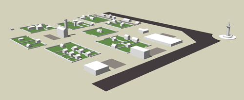
The last process takes place when a large city with many places integrated by many scales of grids develops a mass transit system that becomes more reliable than private transportation systems. When that occurs the need for private transportation falls radically and it becomes possible to live at the centers of this mass transit system without any private transportation, thus radically reducing demand for space. Parking lots can be built over and turned into undifferentiated buildings providing standardized living spaces that can find their match in the very large population. This radically higher population in turn creates a very wide potential for new differentiated networks, and the construction of large buildings is accompanied by many new, differentiated small buildings. This is what enables a place to achieve high density complexity, and we can call it the metropolitan process.

Metropolitan

A small number of larger new buildings accompanies a large number of small new buildings resulting from the reduction in space needed for transportation.

A model such as this one is not meant to be a design to be implemented in reality. It serves only as an illustration of the processes, the means through which decisions are achieved, that generate the structure of cities. If we want to do the morphology of an existing city, it is these processes that will help us explain what decisions led to the city’s present form. These processes also help us predict the future of the model of urban development we choose to adopt. As an example I have become highly critical of measures that seek to increase the density of subdivision developments by smart growth zoning regulations. They tend to leave the structure of neighborhoods in such a state that further subdivision processes within its tissue are impossible, and the neighborhood becomes unable to adapt itself as its population changes. Instead we should be building low density subdivision developments that can grow naturally into metropolitan neighborhoods, and this growth will be controlled by its community as its members make the decision to give up a part of their property to accomodate the changes the community is undergoing.

Organization and intelligence

1. Sun Tzu said: The control of a large force
is the same principle as the control of a few men:
it is merely a question of dividing up their numbers.

2. Fighting with a large army under your command
is nowise different from fighting with a small one:
it is merely a question of instituting signs and signals.
– From The Art of War by Sun Tzu

The problem of social cooperation is how to order many individuals into large-scale patterns, and thus acquire the benefits of these larger patterns. The military arts were the first to face this problem, war being a field where inferiority carries severe consequences, and lessons are learned quickly. The solution was known in the time of Sun Tzu: the superior army was the one that could act as a single force, applying a single decision multiplied by however many men were at the command of this army. More men were always better, but past a certain scale it became unmanageable for a commander to yell out orders to everyone and maintain command. In order to resolve this the military men invented hierarchy, a command structure through which the commander’s orders would be distributed so that a group of any size could act as a single force.

For most of history success in war came from achieving and maintaining organization, lines of command from a center to the individuals that compose an army such that the commander could deploy the army in the most effective pattern he could think of. Discipline and complete obedience to orders was required, even if the situation as it appeared to the lowly grunt was in total contradiction to the orders he had been signaled. As far as he knew, the commander had a larger picture of the war and the orders ought to work out correctly. But the flaw in organization is that as an organization becomes larger, as the layers of hierarchy increase, the commander becomes more remote and more isolated from his army. The lines of communication become inefficient, the orders become irrelevant, and many men die stupidly.

Nevertheless, for centuries the sheer overwhelming force of numbers more than made up for the losses due to bad orders. The principle of organization triumphed. Reformers started looking for plans to organize industries, entire nations (the command economy of the Soviet Union), and of course, cities. The C.I.A.M. Athens Conference resulted in the publication in 1942, by Le Corbusier, of the Athens Charter, the document upon which the plans to organize modern cities, and be rid of the spontaneous historic city, were founded.

Between the time of the Athens Conference and the publication of the Athens Charter, the military concept of large-scale organization was completely discredited.

In June 1940 the German army invaded France. The two armies were evenly matched in men and weapons, France even having a advantage in tanks. Within one month the French army organization collapsed and millions of men surrendered without having put up much of a fight, resulting in many decades of American jokes about French surrender. In reality the two armies were far from evenly matched; the German generals had discovered a mean to overcome the weakness in the principle of organization, that it relied on a central, single commander. Their model of cooperation has been called Blitzkrieg, the lightning war, and its intent was to reduce the delay in receiving and sending the “signs and signals” of command by removing them. German commanders out in the field were given broad directives and trusted to figure out on their own how to fulfill them, with glory and medals as reward for success. The French had instead refined organization and bureaucracy into a precise art. Within days of breaching into France, autonomous German tank divisions destroyed the lines of communication of the French army and paralyzed the front-line units. It became impossible for it to act as a single force, never mind stopping an invasion.

The German system of directive command was in fact the universal principle of emergence applied to military action. Instead of building a hierarchy of orders to communicate the will of a central commander, the armies were organized in parallel, directed to respond to their observed context, a context which was itself produced by other units of the same army. Instead of deploying the intelligence of a single commander holed up in an office in Berlin, the German system linked the intelligence of all of its officers into a more effective super-intelligence that could see all of the battlefield simultaneously. The collapse of the French army was therefore inevitable. It was a case of one against many.

As already mentioned, war teaches quickly, and the allies eventually adopted a similar operations model to fight the war to victory. German operations theorists went on to design the structure of NATO’s European defense, a war that we fortunately never witnessed. Urban planners did not have to learn this lesson, and they opted to organize cities to ruin.

hierarchy-network

The network structure is often, incorrectly, called a “bottom-up” organization. My opinion is that this label makes no sense. There is no up or down in a network. There is neither bottom nor top. Those are descriptions that apply to hierarchies only. In a network actions happen horizontally, in parallel. Large-scale patterns are made up of links between those local actions, as seen in the figure above. Human intelligence, for example, cannot be explained as a collection of cells. It is the patterns formed by the links between these cells that is intelligent, and it is these patterns that allow us humans to be several orders of magnitude more complex than individual cells.

The paralysis inflicted on the French army organization was in parts self-inflicted. Longer chains of command involved delays in transmitting information (reports from the field), analyzing the information, planning a reaction and ordering the new deployment. The bigger the army became, the more paralysis it suffered. This organization was in much the same situation as the dinosaur who did not feel a hit on his tail because the nerves were too far from his brain. The bigger it became, the more exposed it was to a paralysis-focused attack.

It should not come as a surprise that what caused the death of cities is also self-inflicted paralysis. But the case of cities is much more tragic. The German operations model was novel and innovative, a radical improvement in military art. Cities, however, had always been emergent. They were the product of a spontaneous order, a phenomenon that was barely understood at the height of rationalist planning. What science did understand was organization. Since it was accepted as the pinnacle of science, no rational thinker could reject the new urban planning. The planners did not notice the hints: what they were organizing had not been a creation of anyone.

In a complex emergent system, the number of unique patterns scales up with the size of the system. (What some emergence commentators call “more is different,” another expression that makes no sense.) While an organization attempts to create a large-scale pattern to outmatch smaller patterns, a complex system is made up of both small and large patterns, in proportion to a power law, either nested together or juxtaposed randomly (a fractal). If an emergent system is intelligent, it will structure itself into patterns that no one had expected.

For centuries people had been accustomed to such patterns as the street of similar shopkeepers. Many streets in European cities bear the name of a particular trade, such as baker’s street or threadneedle street. But when cities passed a critical scale during the industrial revolution, a whole new pattern emerged: the central business district. An entire city within the city became the center of commerce, not simply specific streets next to residences. Although it appeared unexpectedly during the 19th century (the Haussmannian renovation of the Opera district of Paris was meant to create a neighborhood for the upper classes, but it became a business center immediately and has remained so ever since), a central business district came to be what a major city was all about. When planners set out to organize a modern city, they planned it around the CBD as the central feature. They did this by drawing a square on the map and applying a different set of rules to this square. Within a few years, their CBDs began dying. The small scale patterns nested within them had been zoned out.

In retrospect it was inevitable for an attempt at organization to severely interfere with urban processes, the principle of organization being a step down in complexity from the principle of emergence. Organization had a sinister advantage: it gave the planners the illusion that they could predict what the city was going to become. An emergent system cannot be predicted with precision. The very basis of its intelligence is that it has not yet been decided what it is going to do. Embracing an emergent system means accepting that patterns will appear that are beyond our comprehension. (In Wolfram’s terminology, the system is computationally equivalent to our own intelligence.)

By trusting their front line officers to run the war for themselves, the German general staff took a leap of faith that paid off decisively and confronted every opposing military with their crippling inferiority. I suspect the first modern city to give up on the principle of organization will trigger a similar revolution.

The Fundamentals of Urban Complexity

This is part II in an ongoing series of excerpts of an article set to be published this summer in The International Journal of Architectural Research, tentatively titled The Principles of Emergent Urbanism. Click here for part I, The Journey to Emergence.

The qualities of an emergent city

The adoption of mass-production processes, or development, in substitution for spontaneous urban growth in the mid-20th century created for the first time a phenomenon of alienation between the inhabitants and their environment. While the physical features of spontaneous cities could be traced to complex histories of families, businesses, and organizations, the physical features of planned cities owe their origin only to the act of planning and speculation. This has severe consequences towards the sustainability of place as there will not grow any particular attachment by the residents, their presence there being only a temporary economic necessity and not the outcome of their life’s growth. Mass-production of the environment left people as nothing more than consumers of cities where they used to be their creators. A building culture was replaced with a development industry, leaving the landscape culture-less and with no particular sense of identity. This took place despite the evidence that a building which has a unique history and has been fitted to someone’s life, as opposed to speculatively produced, generates market value for that property. (Alexander, 1975) This is why, although the demolition of so-called “slums” to replace them with modern housing projects created a great deal of opposition against urban renewal programs, the demolition of the housing projects later on did not lead to a popular preservationist opposition. They were not the physical expression of any culture.

In additional to cultural patterns, spontaneous settlements also have a peculiar morphology that has not successfully been imitated by modern growth processes. Spontaneous settlement processes give individuals full freedom to determine the boundaries of their properties. Spontaneous settlement is one where total randomness in building configuration is allowed, with no pre-determined property lines acting as artificial boundaries. Buildings and building lots as such acquire general configurations comparable to cell structure in living tissues, unique sizes and boundaries that are purely adapted to the context in which they were defined. In the absence of abstract property boundaries, property rights are bounded by real physical limits such as a neighbor’s wall. (Hakim, 2007)

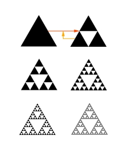
Very attractive spontaneous cities have a specific pattern of the urban tissue. It consists of similar vernacular buildings that appear very simple when considered individually, but produce a visually fascinating landscape when considered as a whole. This is a form of fractal geometry. In mathematics a fractal is a geometric object of infinite scale that is defined recursively, as an equation or computation that feeds back on itself. For example the Sierpinski triangle is defined by three triangles taking the place of one triangle as in figure 4.
Sierpinski_triangle_evolution

Figure 4. A triangle triggers a feedback function that produces three triangles, which themselves trigger the feedback function to produce nine triangles, and so on. This process can unfold as long as computational resources can be invested to increase the complexity of the object.

The Mandelbrot Set is a much more interesting fractal that is defined as a simple recursive mathematical equation, yet requires a computation to visualize in its full complexity. When computing how many cycles of feedback it takes for the equation to escape to infinity for specific coordinates, figure 5 is the outcome.

Mandelbrotset

Figure 5. The image on the right is a deeper magnification of the image on the left, produced with a narrower range of coordinates as the input of the Mandelbrot set’s feedback function.

In addition to its remarkable similarity to natural phenomena, this form of geometric order informs us of a very important law in geometry: a feedback loop that is fed through the same function will produce an ordered but unpredictable geometric pattern out of any random input.

This tells us why cities of vernacular buildings have such appealing geometric properties at the large scale, despite being often shabby and improvised at the scale of individual buildings. Shanties made of scrap metal and tarp look rough at the scale of the material, but because multiple shanties share the construction process and originate from similar feedback conditions they form an ordered geometric pattern with its specific “texture”. The same process takes place at other scales of feedback, for example the production of a door. Whether the input for one door is larger, taller, wider than another door, if the same production process is employed the two doors will contribute to the overall fractal order of the urban space. This law has been employed not only in traditional and spontaneous cities, but also for modern urban planning initiatives. In the New York City neighborhood of Times Square the structure of billboard advertisements is defined by a building code that determines their configuration in relation to the configuration of the building. The outcome is a unique tissue of advertisement billboards that has become more characteristic of the neighborhood than the buildings themselves, which are not produced by a shared feedback function.

Fundamentals of urban complexity

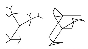
Christopher Alexander showed in A City is not a Tree (Alexander, 1965) that social and economic networks formed complex semi-lattice patterns, but that people who observed them limited their descriptions to a simple mathematical tree of segregated parts and sub-parts, eliminating connections in the process. (Figure 6 compares the structure of a tree and semi-lattice.) In attempting to plan for urban structure, a single human mind, without a supporting computational process, falls back on tree structures to maintain conceptual control of the plan, thus computing below spontaneous urban complexity, a phenomenon that is consistent with Wolfram’s theory of computational irreducibility of complex systems. (Computational irreducibility states that the only accurate description of a complex system is the system itself and that no abstraction or reduction to a simpler process is possible.) Nikos A. Salingaros later detailed the laws of urban networks in Theory of the Urban Web. (Salingaros, 1998) Network connections form between nodes that are complementary, and therefore the complexity of networks depends on an increasing diversity of nodes. Salingaros describes the urban web as a system that is perpetually moving and growing, and in order to do this the urban tissue has to grow and move with it. Consider for example the smallest social network, the family. Debate over accessory units or “granny flats” has intensified as normal aging has forced the elderly out of their neighborhoods and into retirement complexes, while at the other end of the network young adults entering higher education or the labor market vanish from a subdivision, leaving a large homogeneous group of empty-nesters occupying what was once an area full of children, and often forcing school closures (a clear expression of unsustainability).
treelattice

Figure 6. A comparison of a tree pattern on the left and a semi-lattice pattern on the right. The tree structure is made of groups and sub-groups that can be manipulated separately from others. The semi-lattice pattern is purely random without distinct sub-parts.

These social networks grow more complex with increasing building density, but a forced increased in density does not force social networks to grow more complex. For instance the spontaneous settlements of slums in the developing world show remarkable resilience that authorities have had difficulty acknowledging. Because of squalid living conditions authorities have conducted campaigns to trade property in the slum for modern apartments with adequate sanitary conditions. To the authorities’ befuddlement some of the residents later returned to live in the slum in order to once again enjoy the rich social networks that had not factored in the design of the modern apartments and neighborhoods, demonstrating that the modern neighborhoods were less socially sustainable than the slums.

In commercial networks, space syntax research (Hillier, 1996), using a method for ranking nodes of semi-lattice networks, has shown that shops spontaneously organize around the multiple scales of centrality of the urban grid at its whole, creating not only commercial centers but a hierarchy of commercial centers that starts with sporadic local shops along neighborhood centers and goes all the way to a central business district located in the global center of the spatial network. The distribution of shops is therefore a probabilistic function of centrality in the urban grid. Because the information necessary to know one’s place in the hierarchy of large urban grids exceeds what is available at the design stage, and because any act of extension or transformation of the grid changes the optimal paths between any two random points of the city, it is only possible to create a distribution of use through a feedback process that begins with the grid’s real traffic and unfolds in time.

The built equilibrium

Although they may appear to be random, new buildings and developments do not arise randomly. They are programmed when the individuals who inhabit a particular place determine that the current building set no longer provides an acceptable solution to environmental conditions, some resulting from external events but some being the outcome of the process of urban growth itself. It is these contextual conditions that fluctuate randomly and throw the equilibrium of the building set out of balance. In order to restore this equilibrium there will be movement of the urban tissue by the addition or subtraction of a building or other structure. In this way an urban tissue is a system that fluctuates chaotically, but it does so in response to random events in order to restore its equilibrium.

This explains why spontaneous cities achieve a natural, “organic” morphology that art historians have had so much difficulty to describe. Every step in the movement of a spontaneous city is a local adaptation in space and time that is proportional to the length of the feedback loops and the scale of the disequilibrium. For spontaneous cities in societies that experience little change the feedback loops are short and the scale of disequilibrium small, and so the urban tissue will grow by adding sometimes as little as one room at a time to a building. Societies experiencing rapid change will produce very large additions to the urban tissue. For example, the skyscraper index correlates the construction of very tall buildings with economic boom-times, and their completion with economic busts. The physical presence of a skyscraper is thus the representation of a major disequilibrium that had to be resolved. (Thornton, 2005) The morphology of this change is fractal in a similar way that the movement of a stock market is, a pattern that Mandelbrot has studied. In general we can describe the property of a city to adapt to change as a form of time-complexity, where the problems to be solved by the system at one point in time are different from those to be solved at a later point in time. The shorter the time-span between urban tissue transformations, meaning the shorter the feedback loops of urban growth, the closer to equilibrium the urban tissue will be at any particular point in time.

Modern urban plans do not include a dimension of time, and so cannot enable the creation of new networks either internally or externally. They determine an end-state whose objective is to restore a built equilibrium through a large, often highly speculative single effort. They accomplish this by creating a large-scale node on existing networks. In order for such a plan to be attempted the state of disequilibrium in the built environment must have grown large enough to justify the immense expense of the new plan. This is why development will concentrate very large numbers of the same building program in one place, whether it is a cluster of 1000 identical single-family homes or a regional shopping mall, just like the skyscraper concentrates multiple identical floors in one place. Demand for these buildings has become so urgent that they can find a buyer despite the absence of local networks, the standardized building plan, or the monotonous setting. This is not as problematic for large cities for which a single subdivision is only a small share of the total urban fabric, but for smaller towns the same project can double the size of the urban fabric and overshoot the built equilibrium into an opposite and severe disequilibrium.

The mixed-used real estate development has attempted to recreate the sustainable features of the spontaneous city by imitating the morphology of sustainable local economic networks. It has not reintroduced the time dimension in economic network growth. Often this has resulted in a commercial sector that serves not the local neighborhood but the larger region first, consistent with the commercial sector being a product of large-scale economic network disequilibrium. In other developments the commercial sectors have struggled and been kept alive through subsidies from residential development, which is evidence of its unsustainability as part of the system.

References

Alexander, Christopher (1965). ‘A City is not a Tree’, Architectural Forum, vol. 122 no. 2
Alexander, Christopher (1975). The Oregon Experiment, Oxford University Press, USA
Hakim, Besim (2007). ‘Revitalizing Historic Towns and Heritage Districts,’ International Journal of Architectural Research, vol. 1 issue 3
Hillier, Bill (1996). Space is the Machine, Cambridge University Press, UK
Salingaros, Nikos (1998). ‘Theory of the Urban Web’, Journal of Urban Design, vol. 3
Thornton, Mark (2005). ‘Skyscrapers and Business Cycles,’ Quarterly Journal of Austrian Economics, vol. 8 no. 1
Wolfram, Stephen (2002). A New Kind of Science, Wolfram Media, USA

The complex grid

In a medieval-era city the pace of urban growth is slow to a point where the growth of the city is not consciously noticed. Buildings are added sporadically, in random shape and order, as the extremely scarce economic situation makes no other pattern possible. Typically this means that the shape of streets will match the existing natural paths of movement, giving the street network an organic structure that is preserved through successive transformations in the urban fabric.

This works until the street network becomes large enough to become a functional problem. Because it is random, the medieval street network becomes complicated to move around in once the structure exceeds a certain scale. Some people see this as an obstacle to commerce and project to restructure the emergent medieval grid into something more rational. These projects fail for the same economic reasons that shaped the emergence of the medieval streets.

As the pace of urban growth increases and as the cartesian paradigm expands in the 17th and 18th centuries, deliberate city planning through the pre-emptive definition of an urban grid becomes fashionable. The practice of baroque planning remains the privilege of ultra-rich landlords considering the scale of construction involved. (Louis XIV’s Versailles is still the case study.) In the Americas such concentrations of capital do not yet exist. Grids are not truly part of a city plan, they are the outcome of regulations meant to avoid the pitfalls of medieval urban growth. Although the idea of a block is defined, the limiting shape of the grid itself is undefined. This allows cities to grow out, in theory, infinitely.

This works until the grid encounters and existing structure in the landscape. While Europe’s land is already very complex, in America the land is mostly empty. One exception is New York, which has multiple grids expanding towards the center of Manhattan, all with their own alignment with the waterfront. Compounding the medieval streets below Wall Street, the city’s network is getting messy. The solution conceived is the first city plan of New York, the Commissioners’ Plan of 1811, which grids Manhattan in the pattern it is famous for to this day with the help of a concentrated political power. In Europe this much centralization is not available, cities being ringed by a large number of villages that already structure the land. One notable exception is Barcelona, which under conservative military domination had reserved a large non aedificandi zone outside of its defensive walls. With the military out of the picture, and the industrial revolution putting enormous pressure on the city’s growth, the next most famous cartesian grid plan is imposed: the eixample. Adepts of the medieval city such as Camillo Sitte praise its artistic value and quality of life, but fail to truly describe how to reproduce it in the context of accelerating urbanization.

The 19th century is the triumph of the cartesian plan. It is not only employed to plan cities but to plan the entire American landscape. West of the original colonies the map becomes rectilinear. The flexibility and fluidity of New York’s grid plan promotes very rapid land development and the city achieves growth rates never before seen. European city planners are facing the same growth pressure but are trapped by the land’s existing structure, both physical and political. One simple solution is discovered: demolishing city walls and building a high capacity road that encircles the city, the boulevard. If it is to be complicated to get inside a city, it will at least be simple to get around it. Paris builds two on its two successive walls, and Vienna builds the famous Ringstrasse. An interesting phenomenon emerges from subsequent growth. While the boulevards were meant to be restful promenades, they emerge to become important centers on their own due to their attractiveness for traffic. In space syntax terms, they are integrators.

Manhattan’s grid extends to over a hundred streets but starts to suffer from severe scale problems. The medieval street system drives traffic away to boulevards, but in an endless grid traffic goes everywhere, and there is no place that is free of the increasing congestion. With the introduction of the car the endless grid is in crisis. Since no better idea is found, the grid system is replaced with the high-capacity collector road to concentrate all the congestion, from which huge, isolated developments  access each other. This is the suburban sprawl system that remains the norm. It has the advantages of being simple to plan and giving enormous clout to land developers. However people are dissatisfied with the enormous scale of their environment. That they enjoy a single-family home does not sufficiently conceal the fact that they are clustered with thousands of similar homes, and next to those are huge strip malls, office parks and shopping malls that require long vehicle trips to access. The disconnect between their homes and their activities means they live in a form of crowded isolation. The suburbanites escaped congestion only to arrive at emptiness. There is more life in the less populated countryside. Adepts of the metropolitan grid such as Rem Koolhaas praise the culture of congestion as a lifestyle that the collector road fails to create.

This was as briefly stated as I could the modern history of the urban network: one system failing to adapt to the scale of the city, being replaced by a larger system that erases the small scale complexity of the previous only to itself fail at a much larger scale, and then another larger system crushing all complexity to resolve a problem of modernity.

Is there a way that we could have the benefits of all systems balanced as a whole urban network? To describe such a system, we can first define some proscriptions.

  • Any size of urban growth is allowed as long as the new growth extends the boundary of the network. This ensures that the city has the economic flexibility of the medieval city and allows anyone, no matter their economic importance, to contribute to the city’s growth.
  • The network must not become so complicated that it becomes impossible to move around in order to participate in large-scale activities and a culture of congestion.
  • Streets must not grow too long without interruption in such a way that speeding and traffic accidents are encouraged.

How does this work out in terms of prescriptions? It turns out to be very simple. If we assume that we start with a hamlet of a single block, or a regional road that is undeveloped, we need only two rules: one for private development and one for the community.

  • For private development: you may build on any available part of the network so long as you replace the part you used up by extending the network around your new block.
  • For community development: any time a part of the network becomes too complicated (for example it takes more than 4 steps to get out of a sector), extend the boundary of that part with a higher capacity road (a boulevard).

How do we tell if these two rules really do meet the proscriptions we defined? Since we’re talking about an emergent design, the only way to see how it works is to do an explicit simulation of the computations involved. For this I employed a Fibonacci sequence to stand for a random growth process. With each new block that the sequence generated, I placed it in the section of the network that minimized the private cost of extending the boundary. I also used square blocks to simplify the computations involved, and also to demonstrate how such a process would work in a structure of land that has been made square, for better of worse, through cartesian planning. The process would work just as well in a more fluid, rounder land structure such as exists in Europe and the American East.

Stage 1: The village

complex-grid-village

The village is a cluster of houses and small businesses, whose only real challenge is maintaining a facade with the outside by ensuring that every new block also fronts the countryside. This provides the village with a path that everyone can walk around on whenever they want to get some fresh air and open space.

Stage 2: The town

complex-grid-town

The town starts to support development at larger scales with bigger block sizes. The first boulevards are built around the original village, preserving its traditional atmosphere from the growing businesses on the new boulevards.

Stage 3: The city

complex-grid-city

Now a significant regional center, the city’s economic complexity is heralded by the construction of the ring road enclosing the town’s neighborhoods. Large developments such as a regional shopping mall, an airport and a TND line the ring road alongside other smaller blocks of more traditional housing and business that take advantage of the high centrality of the ring and its new culture of congestion, eventually forming whole neighborhoods of their own. The ring road also encloses available green spaces for recreation, making it a parkway in some segments.

Emergent properties of the process

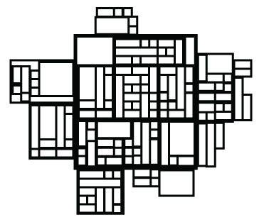
The most interesting outcome is that the structure of the network makes a very nice chaotic fractal, showing the balance between scales in the city’s growth. It is simultaneously simple to grasp and complex, living geometry.

complex-grid-fractal

The spatial integration created by the boulevards and ring roads also promotes the creation of a hierarchy of different centers that are evenly distributed between neighborhoods. Tightly knit residential quarters provide security for children and the elderly, with neighborhood centers within walking distance and no threat of heavy traffic until the edge of the city, liberating citizens from automobile dependency.

Adopting a complex grid is going to benefit small towns and villages most, as their economy is typically not large enough to support the collector road system. It might even result in the emergence of new villages in rural regions that have experienced large-scale urbanization and thus make them more resilient to economic shocks.

For existing cities, history provides a precedent for increasing the grid’s complexity when the problem is scaling up the grid. The urban renovations of Haussmann in Paris or Robert Moses in New York showed how to compose a larger scale within an existing city. (In Moses’ case, how not to do so as well.) However there is no precedent for scaling down a network that is too big, which is what modern cities suffer from. I suspect that contrary to scaling up which requires a strong centralization of power, scaling down involves a decentralization and a multiplicity of new powers transforming neighborhoods, breaking up regional, municipal and even neighborhood authorities such as homeowners’ associations to create local economies.

How they build today in Palestine

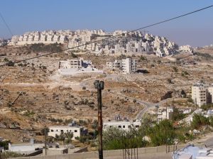
Har Homa Settlement

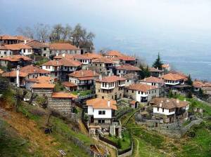
This is the Har Homa settlement, a suburb of Jerusalem built during the 1990’s. It is the perfect example of an attempt to imitate the complex form of the traditional hill town without employing any of the same processes. As a result the repetition of shapes at the scale of buildings gives away the production process as a type II physical phenomenon and not a complex living environment. Who could truly love it?

To quote James Howard Kunstler, in a region where his words have a much more urgent significance, will this be a place worth defending?

Regional complexity and local community

The housing crisis afflicting Britain has reached such an intolerable level that Prime Minister Gordon Brown is announcing what amounts to a nationalization of planning regulations (report via Planetizen). This comes on the heels of the mayor of Greater London being granted the power to override planning rules of boroughs in order solve the capital’s even more outrageous housing situation, as recently as 2007. The trend towards centralization of the planning process must mean that England is suffering from too much localism. Since the glorious standoff between Robert Moses and the mothers of Greenwhich Village in the 1950’s, the local area has been considered the appropriate scale for urban planning, leading in New York City to a transfer of planning rights to community boards. This transfer has not been without its drawbacks to the city. With the reputation of Robert Moses being slowly rehabilitated the pendulum may be swinging back in the other direction.

The Paris region has struggled with the same issues, having had both its Robert Moses era and now its localism era leading to the same kind of crisis London is struggling with. Legislators and senators have lately been juggling with different schemes to solve the problem of Greater Paris, all of them more or less inspired by the Greater London Authority. (The humiliating loss to London in the bid for the 2012 Olympics having provided the evidence for the superiority of London’s model.) Localism in France is notoriously entrenched, the Ile-de-France region being divided into over 1200 communities, one third of them creating the 10,000,000 people Paris metropolis. Planning a world-class capital with 1200 mayors, all out to protect their local community and identity, has to this day been achieved by layering multiple superimposed regional authorities that have fought each other in turf wars and become a remote abstraction to the citizens they are little accountable to. When finally things achieve complete irrationality, people plead for the state to step in.

What’s unusual about this situation is that it is not the first time it has happened. It is another round in a cycle whose last peak was the post-war housing crisis that lead to the regional plan of Paul Delouvrier under special orders from then-president of France Charles de Gaulle. Going back further in history, the nomination of prefect Georges Eugène Haussmann and his restructuring plan to extend the scale of Paris was preceded by a similar urban humiliation against London. Both times public opinion turned against the regional planners a decade or two into their rule, giving way to another era of localism. In the meantime their projects, the great boulevards and the Regional Express train network, became indispensable to urban life.

Over the summer I was fortunate enough to be on the planning staff of one Delouvrier’s great projects for the Paris region, the New Town of Saint-Quentin-en-Yvelines, today a mature city. The city has since its founding been a microcosm of the regional-local conflict. From that experience I proposed a permanent solution to the cycle, and my inspiration came from fractal geometry.

The problem to be solved is to create a division of the metropolis that is simultaneously local and regional, that allows local communities to grow through their own specific urban processes while making it possible to launch and plan projects at the regional scale. The divisions have to be simple enough internally that people can easily understand how they work, thus forbidding the layering of levels of governance and bureaucracies, the territorial mille-feuilles. The closest object that describes such an organization is the Sierpinski Carpet.

The Sierpinski carpet is an object that has structure at infinite levels of scale and can therefore solve problems that occur at the biggest and smallest scales. In real-world terms, it implies that a regional community has grown around small communities and towns, each with their own separate and contrasting scale. This organization recognizes that cities happen at all scales and harmonizes them into a coherent whole. It is a fractal, perforated city.

The city of Saint-Quentin-en-Yvelines is a clear attempt, although a failed one, to create such a perforated city. The original territory, on the outskirts of Paris just south of Versailles, was a sleepy exurban territory of one small town and a handful of villages surrounded by large farming estates, when in the late 1960’s the state launched its program of new towns. Because the farming estates were concentrated in the hands of a few large farmers the state considered them easy to acquire and develop. A state-owned developer, EPASQY, was created to develop and commercialize the new town, and a special regime of planning regulations was created around the existing town and villages, preserving the local rules within them. This territorial organization had the following form:

zan

The gray area was the territory controlled by the developer. The white pockets were the town of Trappes and the villages and hamlets of the area. The other significant aspect of this organization, and what eventually caused the hijacking of the New Town project, is the superposition of the communes divisions onto this structure. The commune is the basic element of local governance in France, created during the French revolution and static ever since. While the local mayors of the communes tried in vain to stop the plan, the arrival of suburban migrants from Paris into the new neighborhoods spelled the end of their community. In one fateful year every mayor was swept from office and replaced with more politically-savvy migrants from Paris who proceeded to create a new, suburban community from their office by blocking the plans of the state developer and acquiring the right to determine the programs of all further developments. What was to be a New Town of 500,000, an economic and political balance to Paris as the state designed it, was thus scaled down to what it is today, a suburban city of over 100,000 made up of 7 semi-autonomous and politically antagonistic communities struggling to solve regional problems since the dissolution of the developer.

Because the territory of the local communities extended beyond their urbanized area, the urbanization of this land by migrants from another community, that of metropolitan Paris, caused their community to disappear politically. This problem is the root of the housing crisis in London, Paris and rural England. Communities are not able to grow their territory as they expand, and smaller communities with territories much greater than they need must protect their political existence by restricting the production of new housing that will threaten their political future. If, by some accident, any one of the hundreds of communes of Paris were to remove density restrictions, the result would be the entire housing demand for the region channeled in this one community, creating a population surge followed by a new political paradigm. Mayors therefore naturally block new development, and will fight proposals such as Mr. Gordon Brown’s to overrule their community’s planning regulations. Their very survival as a political community is at stake. Had the New Town planners been able to create new political territories that preserved the local communities in the middle of their plan, both the local communities and the new regional community could have coexisted. Instead they both vanished in favor of artificial suburban communities in the fight over the area’s development.

Anyone traveling around the Paris region will be easily persuaded of the necessity of preserving local communities, some of which have had a distinct existence since before the middle ages. One historic town, Saint-Germain-en-Laye, has the claim of being the birthplace of the French kings. Other communities have not enjoyed political autonomy since Haussmann’s reforms, but continue to exist in fact. The village of Montmartre has enjoyed a special planning code within Paris’ planning system until recent year, as have the outer boroughs. These distinct processes were abolished in this decade’s revision of the planning system and a single planning system now regulates all of Paris in the hopes of simplifying the process. The drawback will be the loss of Paris’ distinct communities.

The solution to the dilemma of Greater Paris and its many communities would be to create a perforated fractal Paris, with distinct communities and their distinct planning processes existing autonomously within it. The most significant of these communities, and the one most people recognize as Paris, is the historic core of boroughs 1-12. This area has developed a tourism-centric economy that requires a planning process focused on strict preservation of the urban fabric, or as other Parisians call it, a museum-city. Beyond that circle begins metropolitan Paris, the space centered around the two ring highways, which faces entirely different challenges and community objectives.

opera st-michel

Historic Paris – beloved by tourists

courbevoie-gare porte-de-saint-denis

Metropolitan Paris – home to millions with different challenges and a different urbanism

montmartre-village

Village of Montmartre, an enclave within Paris

Within the regional city of Paris would exist other historic cities as well as special forms of communities, such as the business city of La Défense whose unconventional urbanism preserves the economic vitality of the region. Alongside major historic towns such as Versailles and St-Denis, the territory of Metropolitan Paris would also be perforated by a constellation of villages and perhaps some entirely artificial and experimental communities.

For the legislators tasked with drawing community boundaries, such a plan will be a nightmare. How are they expected to define thousands of communities, each with their scale, and track their growth over time? The task is impossible. They have imposed the delimitation of communes in a central plan that is every bit a form of zoning as the separation of uses, and just as limiting, because that is the limit of their ability to control communities. A fractal territorial structure of thousands of communities cannot be made by legislative act, it must be an emergent outcome of autonomous communities exchanging parts of their territory until they have achieved an equilibrium that fits all of their current situations. For this the legislators must give up defining the boundaries and instead define a process by which communities are formed and grow out of other communities.

Cities have grown upon a political blueprint that did not adapt with the communities it planned for. This created regional crises that were followed by regional blueprints and then local crises. A dynamic territorial structure would not adopt a regional or local scale but all scales at once, nested within each other. Such a territorial structure would result in institutional simplicity while resolving regional complexities in its emergent dimension. Doing so implies that legislators and governments must give up their power to plan communities, an act they will be reluctant to consider.

Interesting side-note

While New York City’s growth rarely bumped into an existing community, one case was Greenwhich Village, which today continues to be an exception in Manhattan’s otherwise strict urban grid. How strange that it would be the Greenwhich Village community that would stop Robert Moses more than a century after joining the metropolis.

Update

Another story on community conflicts appears on Planetizen, this time about an Amish community being forced by a local municipality to comply with a planning process that will destroy their community. The city demands that the Amish submit engineering plans for their buildings, but traditional buildings are not engineering projects. If they start building from an engineering plan, the form the buildings take will be completely different from their traditional form, and the building culture will die out.

Design, configuration and natural form

When did human creations stop being natural? We look at a tower block, a subdivision or a shopping mall parking lot and see the worst of industrial civilization translated into form. We tolerate them as necessary to achieve the material wealth of our civilization. Those human settlements that are still natural we grant special protections through UNESCO and historical preservation laws. We do not have a law that promotes the creation of new historic settlements because we are not quite sure how they are made.

I believe that our mistake is not in the things we make, that there is nothing unnatural about a shopping mall parking lot from a design point of view. What makes the shopping mall parking lots we build so unnatural are errors in configuration of the design elements. To understand this, one must understand the difference between design and configuration.

The form of a tree is an ideal example to illustrate the difference between the two concepts. Any particular species of tree will have a design that is essentially the same from one tree to the next. The design elements in the tree are all the named parts: trunk, branch, leaf, root, bark, and so on. These parts are organized into hierarchical relationships with the whole tree and with each other. We will always find the roots related with the trunk in the same way. This relationship is a design solution that achieves a specific result. However, the position of any of the parts is not fixed. In the DNA of the tree are rules that instruct cells to adapt themselves to the larger context the tree finds itself in. The different design solutions that result from this cellular action will therefore adopt a position that reflects the particulars of time and place, ensuring that the tree’s form is perfectly adapted to its environment. This is why it makes no sense to create a description of the forms of a leaf in order to make another leaf – that form is relevant only to this particular leaf, and another leaf, although it would have the same overall design of parts, will take a completely different configuration.

Adapted to chaos

A chaotic configuration of a standard design

If you’re having trouble seeing this, imagine the following scenario: we take the DNA of a tree and clone it 100 times. Then we lay out a grid 10 trees by 10 trees and watch them grow. What would happen would be that every tree would come out a different way, since the earth around them would be structured differently, the wind patterns would be different, the shade and the moisture would be different. The trees would each have the chaotic, random shape that we know trees to have, yet would all be perfectly symmetrical with one another without being identical. Each clone would adopt a unique configuration of the same design.

When we look at a traditional village, we find that the same house design is repeated time and time again, but configured in such a way that it is differently adapted than the other houses. The reiteration of an often very simple design is all that it takes to create a natural landscape, so long as each house is configured to adapt to its place, and the design elements of the house are themselves configured to adapt to these adaptations.

One design, many configurations

Even today this kind of natural adaptation takes place in modern settlements where planning regulation allows it, or fails at forbidding it.

Monaco

This is the skyline of Monaco, which by necessity of the small size of the city had to be built piecemeal but yet is still made with an entirely modern building stock. The piecemeal process allowed each building to be configured to its site and thus, despite the fact that the buildings’ design is very basic modern architecture, the whole landscape looks natural. It would be even more natural were the architectural elements also adapted.

favela_rocinha_rio

This the Rocinha favela of Rio de Janeiro. Here the building design is as bare as could be made, the houses being built by poor residents with little capital to invest. But the resulting configurations adapt perfectly to the shape of the hill and the other buildings, and the overall look of the place is that of a human jungle. (If you have the chance to see this summer’s The Incredible Hulk, the movie makes this point by fading from an overhead shot of Rocinha to that of a tropical jungle, subtlety be damned.) The buildings in Rocinha are just as natural as the trees.

How does that translate back into our shopping mall parking lot? It means that although the relationship between the parts, for example the lanes, the spaces and the paint that demarcates them, must be defined, the length of the spaces or the thickness of the demarcations do not have to be identical from one element to another. The chaos of nature requires that they be slightly different from one to the next, and that means that the people who make them must be able to make decisions while they are building. Simply copying an AutoCAD drawing is unnatural. The design must be translated into a language that instructs the builders to make configuration choices while constructing the defined forms. This kind of language is how builders have made traditional towns and how DNA makes organisms.

Separating design from configuration also allows us to make a second attempt at city planning. The plans of modernists all had fixed configurations, and their failure to adapt to their context meant the failure of urban planning. The conflict between design and configuration planning dates back even further, to the 19th century plans for Barcelona and Paris. In Barcelona, Cerda planned a grid of square blocks through which he ran grand diagonal avenues. Those were only two design elements in a very strict configuration that was made possible only by the enormous economic pressure to expand Barcelona. In Paris, Haussmann did not have the luxury of expanding the city with blocks, he had to upgrade a city of blocks that already existed with a new design element, the grand avenue. He deliberately left the configuration of his avenues open until they were completed, and placed them where he met the least resistance. Their effect on Paris is even today essential to life, and they could not have been realized unless their configuration was left adaptive.

What would a natural urban design look like? It must first be a definition of parts that must be related to each other in order to create urbanity. Describe the relationship between the avenue and the streets, the streets and the alleys, describe the relationship between the avenue and the pavement, the pedestrian crosswalks and the shade trees. Describe the relationships with the buildings without delimiting their size and shape. The city builders will then decide in what configuration these elements need to be to fit their context, and the resulting built form of the city plan will be perfectly natural as well as fully planned.

Classicism describes itself as the imitation of nature. Complexity, on the other hand, does not imitate. It is nature, applied to different problems. To create the urban design of our time requires not adopting a certain style or program, but ensuring that any style or program can be adapted to a particular context. It only requires us to use different tools than what we have become accustomed to.

Further reading:

Complex geometry and structured chaos, part I and part II.

The challenge of dense sprawl

When looking at such a picture we are at first inclined to make a parallel with the landscape of Los Angeles. It is a foggy urban plain with a cluster of towers popping out over the horizon. This is Dubai from a perspective that is rarely shown, that of the city in the foreground, and its suburban expansions in the background. The towers are the Dubai suburbs, lined up on what used to be the main highway out to Abu Dhabi, now the centre of New Dubai and the urban fringe of Dubai. A picture such as this is significant because the central core of Dubai is almost never seen in the pictures of the huge developments going up in its suburbs. That is unfortunate, since the reason that these suburban developments are economically possible at their size is because they are growths of the old Dubai. The parallel with Los Angeles is therefore incorrect. Los Angeles followed the standard American model of urban growth, developing a central business district on a simple grid where the original center of the city was founded, then later adopted suburban sprawl to continue its growth and grew a cluster of skyscrapers adapted to this sprawl where the center once was. The policy of sprawl is blamed for the impossible traffic congestion that cripples Los Angeles, but generally what is meant by sprawl are the low-density housing subdivisions, office zones and other standard typologies of suburbia. The solution that was called for was more density, even though some geographers pointed out that Los Angeles was already one of the densest cities in America. The result of this choice has been dense sprawl: worse traffic, worse crowding and seemingly no improvement in quality of life.

Clearly the challenge of sprawl has been improperly identified. I will show that sprawl is not about density but about distance between complements, and the extremely rapid urban growth of Dubai, from a small fishing town to an urban metropolis in two generations, makes this visibly explicit.

Perhaps the most fascinating fact about Dubai is how natural and complex the old city seems to be despite having an entirely modern building stock. Most cities associated with a natural or organic morphology are usually pre-modernist cities of old classical or vernacular buildings, or at least preserve some of them. There are no such buildings in Dubai, the city having started its growth period in the 1950’s. The only explanation for the natural form of the old Dubai is a natural process of growth.

The urban fabric of a city is a solution set, each building being a solution to a problem of a particular time and place. The city as a whole is a solution set for its population as a whole, and as times and people change new buildings are added to provide new solutions to these new problems. The reason that naturally grown cities have a chaotic morphology is the same reason why stock market movement is fractal; they are both adaptations to fluctuating circumstances, and they are both limited in size by the previous size of the system. That means that you cannot grow a city by a development that is bigger than the city’s current state of maladaptation to circumstances. Attempting to do so will result in economic failure. Many very small development operations done in succession will be much more adaptive than one large development operation planned at one moment, since each operation adapts to the circumstances created by the previous one.

Because cities grow by correcting maladaptations, the new buildings turn out to be complements of the existing buildings. It makes no sense to make a building that is identical to one that already exists, and in natural cities that will never appear. Each building will be fitted to the particular knowledge of time and place, as Hayek would say. This particular knowledge is itself produced by the presence of existing buildings and the way people use them.

This process is not simply an economic abstraction, it also has morphological consequences.

Jumeirah is a beachfront suburb directly to the south of old Dubai that has become the home of the Anglosphere expatriate community as well as synonymous with upper-class lifestyles. Because it is more recent growth of Dubai’s urban centre it has seen growth in operations of much larger sizes. You can tell that there are now “clusters” of identical buildings, nothing of the scale of a metropolitan subdivision yet, but the building individuality of central Dubai is no longer present. (Cluster housing development is also visible in, for example, the older parts of Las Vegas.) This is pre-subdivision scale, in that an operation creates multiple buildings without having a scale large enough to be “planned” and have status as a named development. For the purpose of the adaptation they bring, they are still only one event, only one adaptation subdivided into multiple buildings. And because they are much bigger than the previous development operations, they create more distance between themselves and the urban fabric they are adapting to. The scale of development is not big enough to be called sprawl yet, but the complexity of this neighborhood is not as advanced as that of the older city. While the buildings in Jumeirah are certainly complements of the whole city of Dubai, they are not complements of each other, which is true in the older city.

Left: Skyscrapers on Sheik Zayed Road, Burj Dubai site on lower left

Right: Palm Jumeirah, Dubai Marina megaprojects along with random subdivisions.

Here are Dubai’s world-famous megadevelopments, which have been made possible as adaptations to Dubai’s metropolitan scale. The development operations are enormous complements of the existing urban fabric, but the fact that they are all being built concurrently means that they cannot adapt and become complements to each other. With little surprise the traffic congestion on the Sheik Zayed Road that integrates them together has skyrocketed. The distance between complements has increased to the scale of the projects, and the only way to move from one to another is by driving down Sheik Zayed Road.

The skyscrapers going up are actually making sprawl worse the same way that a development of 100 houses extends sprawl. The idea that a skyscraper is a vertical city is a myth. Skyscrapers are identical floors of open space and rely on very large networks of complementary urban fabric to work properly. Skyscrapers can contribute to the complexity of a place like New York City because the urban fabric of Manhattan is very rich and can digest density and congestion gracefully, but in a city where urban fabric is undeveloped, as modernist plans for a Radiant City were, or has been de-developed, like the CBD of most American cities, skyscrapers throw congestion and traffic out to the whole city as badly as a housing subdivision.

The solution to sprawl is not increasing density, but increasing complementarity. That means breaking up existing housing subdivisions, office parks and shopping centers into smaller autonomous parts that can grow into buildings that are complements to houses, offices and shops as well as complements to the city as a whole. (This obviously implies abolishing zoning.) It means not trying to design everything that goes into one project, to let growth come to you and to accomodate it, to publicize the chaotic symmetry of old Dubai as a model of natural beauty instead of the iconic forms of the skyscraper cluster. The Dubai Palms and the Burj Dubai district may still grow into something natural and complex.