Category Archives: Example

The patterns of place

(This article originally appeared in Get Ahead Magazine, for the Get Ahead Festival of independent short films in Brooklyn.)

When we speak of the identity of a place, we express a recognition of the patterns formed around us. We may not be conscious of them to the point of being able to draw them back with precision like Stephen Wiltshire, but we can remember them in the abstract, and in this way, identify different places from the abstractions we recall of their patterns. This is how one street can look sufficiently alike another that we can identify a neighborhood, and it is also why a landscape like Liberty City in Grand Theft Auto can feel like New York City, despite the fact that every object has been reconfigured to create a parody environment.

A city’s identity is made by the patterns selected by the people who built them. We can also say that these patterns are the fossil record of the people who inhabited a place. We can read the history, the culture and the sustainability of a place by the combination of its patterns. A building is a hierarchical computation of different processes nested within each other, and these processes can be substituted for others depending on what conditions are encountered.

Echoes of Holland

At the largest scale of patterns there is the building program, whether a house, a church, an office, easily recognizable in any cultural setting. These programs are realized using construction techniques that are conditioned on economic constraints. The Dutch who settled New York City brought with them their basic house program, but these had to adapt to the resources available by, for example, building in brownstone, an economic pattern. Despite this difference they kept features of their homes like stoops, patterns that were at first environmental but then became cultural.

As each successive culture either migrates to or emerges in the city, it needs to adapt the patterns of its buildings to fit its own practices. Fractals like these become habitual:

This is Chinatown in Brooklyn. We can tell it is Brooklyn because the basic patterns, program and materials, are Americanized Dutch. We can tell it is Chinatown because of the use of vertical commercial signs which are characteristic of oriental cultures (their writing being read top-to-bottom instead of left-to-right). The large-scale patterns are extended by smaller-scale patterns to form a full building fractal that is Dutch, American, New York and Chinese. This combination of pattern is the identity of Brooklyn, the people who have lived there and continue to live there.

One particular culture that has often been denounced as an anti-culture is the global corporation. Their aesthetic program has been to impose their corporate identity uniformly on communities, regardless of any consideration for local economic, environmental, or cultural factors. But there have been exceptions, such as the following case, where the corporation decided to extend the patterns of the neighborhood instead of imposing its own.

This Dunkin’ Donuts nested itself seamlessly in an old Dutch building next to a Chinese restaurant, and even improved upon it a bit with orange awnings that preserve the structure of the windows while announcing the presence of this corporate neighbor to everyone on the street. As well as being a demonstration of Dunkin’s neighborliness, it is also a demonstration of the sustainability of the neighborhood. The buildings are resilient, and despite the Dutch builders never anticipating that there could ever exist such a thing as a Dunkin’ Donuts, their patterns have been slightly adapted to fit today’s needs. Some day Dunkin’ Donuts will also be history. In its place will be some other culture which may or may not preserve traces of Dunkin’s presence, but the building itself will remain and serve a new purpose.

So far I haven’t said a word about architecture, which is simply because architecture does not enter the picture unless one has a lot of money for sculptural elements. It is possible to build a good neighborhood without architects, but a great one needs art, and that means getting some architects involved. The best architecture starts with utilitarian patterns, the same functional, economic and cultural patterns we see above, and then expands it by nesting sculptural elements, thus it is still possible to recognize identity of place behind the architecture. This architecture, sculpting the utilitarian shape of the building, becomes the final expression of identity, the artistic currents and fashions that propagate across cultures and then vanish, only to make periodic comebacks.

This is what Brooklyn architects did with these residential towers overlooking prospect park. What is in essence a stack of identical apartments made with the usual economic patterns was extended with sculptural ornament, most impressively around the otherwise obnoxious elevator shafts.

Looking at Brooklyn’s tallest landmark, the Williamsburg Savings Bank Tower, we see patterns that are Gothic, Romanesque, Italian renaissance, Art Deco, all nested within each other and wrapped around a stack of floors that can fulfill any purpose whatsoever. The final product is a building that is worth preserving from a bank, to dentist’s offices, to residences, because the patterns cooperate with each other instead of clashing, and answer our need to feel connected to any of these identities. This is another form of sustainability.

The tragedy of architecture in the 20th century, and the great confusion that came from it, is that modernist architects first banned sculptural elements in favor of purely standardized, globally uniform, utilitarian industrial patterns, then post-modernist architects declared that a building was only a sculpture for living, that the utilitarian should be subordinated to the architect’s artistic expression. The outcome has been a building culture that has no identity when it is not completely incomprehensible, and more than likely has no resilience and no future.

This “Dance Center” is a sad example of this confusion. Were it not spelled out in letters, would we be able to understand anything about this building’s identity? The people who occupy it? What any of its parts do, or if they do nothing at all and are simply there for visual effect? I can’t imagine a future for it. But there is worse.

This building makes no attempt at being anything other than mass human storage, the modernist tower block revived for the bubble epoch. It will likely be a financial failure for being too ambitious while being too redundant. If I were to take an apartment there, it would be impossible for me to tell which window is mine from the outside. What does this say about the people who built it? That they took the easiest path to financial income. What does this say about the people who will live there? That they have nowhere else to go. It is and will remain an alien in the neighborhood, a product that removes identity instead of contributing to it.

Today’s planning establishment attempts to reform the shape of our cities with “form-based codes” that dictate with precision the shape of every pattern. This comes at the cost of outlawing certain unforeseeable patterns that may make a net contribution to the identity of place. It also drives away people that need these patterns, and drains life that is needed to renew the neighborhoods. Last of all, it will not stop a monster like the example above. If instead of dictating shapes, we made it clear how to expand and preserve the neighborhood’s identity, we would all be much freer to live and express ourselves, adding to the history of our environment.

An empty city for sale

If we needed any further confirmation that China is the champion builder of sprawl in this decade (sorry America, you don’t even come close against things like Dubai Marina), this reporter traveled to an entire city built by developers in Inner Mongolia, that, it turns out, no one wants to move to because there is no economy there, as compared to the traditional city down the road.

The economic dimension problem of sprawl building is shown here as evidently as it can be shown.

Poundbury in China

Thames Town in Songjiang New City, Shanghai.

PoundburyInChina

BritainInChina

While creating a semblance of traditional European urbanism, Thames Town is only one enormous block of an entire new city of enormous developments, most in the Chinese style of giant aligned slabs. Far from creating a “new” urbanism, this development needs the enormous scale of modern Chinese urbanism to exist.

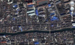
Down the canal from Thames Town’s lake, traditional Chinese organic urbanism persists, waiting to be rediscovered and adapted to the modern age and the enormous scale it requires.

TraditionalChina

Updated:

This great CBS News video report of the construction of Thames Town showed up in the WordPress automagically related links. (Thank you WordPress!) It shows the quality of the construction contrasted with the disappointment the Chinese feel about the social life of these environments. Sprawl alienation is truly a universal phenomenon.

Decoding Sidi Bou Sa’id

sidibousaid

Besim S. Hakim has recently published a new edition of the study of the village of Sidi Bou Sa’id in Tunisia, the project that began his career decrypting the processes underlying the emergent morphology of Mediterranean towns.

In light of the major developments complexity science has made in the decades since, the preface of the new edition puts things in their updated context.

This preface was written in January 2009, thirty-one years after the first publication of this book in 1978. I have decided to re-publish it now due to its importance as an example of a built environment that came into being due to a generative system that is based on a sustainable framework of decision-making characterized by a bottom-up approach and guided by overarching generative proscriptive codes. The emergent result is a dynamic complex built environment that is not the brainchild of a master planner or architect. The exact configurations and form of the built environment is not known during the process of its formation and has a characteristic of unpredictability. This is one of the main features in natural systems that are associated with the phenomenon of emergence. What is known is that the result would fit well and in full balance within its immediate surroundings and will be a contribution that would maintain the integrity and quality of the village as a whole. The process is a result of small acts that in aggregate produces built form that is compatible with its immediate neighbors and that contributes to the high quality of the village’s character. I have researched and published in recent years numerous studies that explain how such an underlying generative system works. – Besim S. Hakim.

This kind of study is essential if we are to reinvent an urbanism that is truly traditional in nature and complex enough to achieve modern sustainability.

Michael Mehaffy’s review provides more context.

The subject of urban codes is now much-discussed in the fields of urban planning and architecture. But most codes are relatively static, specifying an end state to be achieved at one point in time. What Hakim describes here is a much more dynamic, rule-based process of shaping growth – more in line with the latest insights of complexity science about the growth of natural systems. It leads to the phenomenon of “emergence” – the appearance of unplanned and often unpredictable characteristics, that nonetheless have the characteristic of reinforcing and enriching what came before.

Hakim makes a comparison to the work of Christopher Alexander, who has focused on the way that settlements grow over time. Hakim notes a number of “patterns” that correspond to Alexander’s “pattern language” — a compendium of recurrent design solutions, together with the rules that govern how they go together, like the rules of grammar. Alexander argues that such patterned growth over time has produced the beautiful and complex places all around us, in contrast to our more “mechanical” methods today.

For Hakim, such places have achieved a form of sustainability that is well worth our study, since so many of them have, after all, “sustained” for centuries. The subject of urban sustainability is of course a much-discussed one, since buildings and urban environments are responsible for over one-third of the greenhouse gases that cause climate change, to say nothing of other ecological damage. But as many critics point out, sustainability is not just a bolt-on affair: it goes to the way people interact socially and economically, and the way, as Hakim points out, that small acts contribute (or don’t) to the quality and durability of their surroundings, and the built environment as a whole.

If you are interested in the contrasting principles of traditional urbanism as opposed to traditional architecture in a modern planning system, this book can be your guide.

Sidi Bou Sa’id, Tunisia: Structure and Form of a Mediterranean Village

edited by Besim S. Hakim

Lake country

In the outskirts of Miami, ill-thought subdivision development codes require developers to build on-site water reservoirs. The result is a patchwork of unconnected pools.

lakecountryt

When the Dutch ran into similar problems they built canals and then built their cities around them. Shirking their responsibilities, the planners in Florida only build the standard road grid as the integrator, and transfer all other burdens upon land subdividers, who build at a scale unsuited to the required structure.

Also noticeable is the housing density of Miami increasing outwards, where the newest subdivisions are much denser than the older ones, inverting the natural and historic fabric of cities, and wiping away all established stereotypes about suburban sprawl.

Modeling the processes of urban emergence

Placelife

The growth process of an emergent city actually consists of five growth processes. These processes are hierarchically related, that is to say the morphology decided by processes at higher levels of complexity depends on decisions taken at lower levels of complexity. They are not constrained by one another, as modern planners claim when they clear slums in order to build their architectural vision, but expand upon one another, creating a landscape that is tied to a history of adaptation and transformation in order to meet the needs of the present at every point in time.

Each transformation is the decision of an individual, acting within the context he perceives and the ends that are identified. These ends may be within his own sphere of life, by expanding his home, or subdividing his property to build a home for his grown children, but more likely they are the consequences of identifying a potential created by the individual actions of others. For example, if a sufficient number of neighbors have settled, opening a bakery. In this way networks are built upon the potentials created by the last network extension, (in one such instance by capturing residual movement in the grid as Bill Hillier describes) and the city increases in complexity.

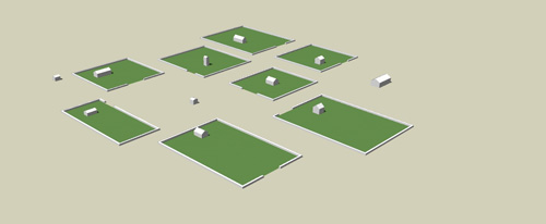
The foundation process of a city, before anyone can even imagine a city being there, I call the place. A place is nothing more than a free surface available to be settled. Newcomers build their home wherever they want in the place, and that implies that they will locate their homes to take maximum advantage of natural features, and space themselves away from their neighbors in order to avoid conflicts over the use of common lands. A place settlement process is how shantytowns are created, except that because there does not exist any functional land ownership in a shantytown there is no limit to how many buildings can be created. Thus the shantytown never reaches the second process of urban emergence, creating a crisis. A place may be created deliberately, by transforming a farm or other types of land use to that purpose, by building fortifications within which land is protected from harm, or a place may be given by nature simply by being available and strategically located.

Place

A place is an open space where people may settle and build randomly

As places become increasingly dense, the use of space by neighbors will create conflicts of proximity. Land will no longer be superabundant. In order to resolve these conflicts a process of land enclosure delimits the boundaries between neighbors’ households by negotiating the boundaries of land that is in private and common use. Streets and blocks thus appear, and those spaces where common use is particularly intensive, because of highly valuable natural features or central locations, become recognized as public squares and greens.

Enclosure

Enclosures delimit private and public spaces, and the pattern of streets, blocks and squares emerges.

With available land to settle either enclosed or occupied by public activities, it becomes more difficult for new growth to take place. New buildings built on remaining place must be justified before a community increasingly protective of the remaining open space. In most cases it is much simpler to ask one of the members of the community to give up a part of his property in order to grow the new part of the town, introducing the process of subdivision. These subdivisions are negotiated case-by-case and thus adopt random sizes and shapes, creating a fractal distribution of lot sizes over a long timeline. Some subdivisions split the land into shared courtyards and cul-de-sacs that are administered under a co-property agreement (they never need to involve the community as a whole).

Subdivision

Properties are subdivided to make room for new growth and new network relationships now that open land is in short supply.

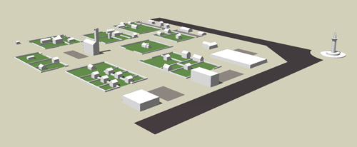
Eventually crowding becomes problematic at the same time as the scale of network growth is increasing due to higher population densities. This creates the opportunity not only to open new places to settlement, but also to connect the central city to these new places by a place functioning at a greater scale, near a road or highway, and that provides an encircling bypass around smaller-scale neighborhoods. This is the grid process. This new construction opens up land to construct large market and industrial businesses that are simultaneously a buffer between smaller-scale places and roads but also an integrator of these places into larger-scale networks.

Grid

The grid integrates mature places into a larger network of places, and creates new spontaneous development opportunities.

The last process takes place when a large city with many places integrated by many scales of grids develops a mass transit system that becomes more reliable than private transportation systems. When that occurs the need for private transportation falls radically and it becomes possible to live at the centers of this mass transit system without any private transportation, thus radically reducing demand for space. Parking lots can be built over and turned into undifferentiated buildings providing standardized living spaces that can find their match in the very large population. This radically higher population in turn creates a very wide potential for new differentiated networks, and the construction of large buildings is accompanied by many new, differentiated small buildings. This is what enables a place to achieve high density complexity, and we can call it the metropolitan process.

Metropolitan

A small number of larger new buildings accompanies a large number of small new buildings resulting from the reduction in space needed for transportation.

A model such as this one is not meant to be a design to be implemented in reality. It serves only as an illustration of the processes, the means through which decisions are achieved, that generate the structure of cities. If we want to do the morphology of an existing city, it is these processes that will help us explain what decisions led to the city’s present form. These processes also help us predict the future of the model of urban development we choose to adopt. As an example I have become highly critical of measures that seek to increase the density of subdivision developments by smart growth zoning regulations. They tend to leave the structure of neighborhoods in such a state that further subdivision processes within its tissue are impossible, and the neighborhood becomes unable to adapt itself as its population changes. Instead we should be building low density subdivision developments that can grow naturally into metropolitan neighborhoods, and this growth will be controlled by its community as its members make the decision to give up a part of their property to accomodate the changes the community is undergoing.

The geometry of nowhere

I hate sidewalks.

When I arrived in Paris the first shock I felt was how much space there was for people to move around. Even on boulevards with little pedestrian traffic, such as Boulevard Port-Royal, space is divided equally between pedestrian standing room, in other words place, and roads for vehicles. How many modern cities offer this kind of abundance? While, like all tourists, I loved the boulevards in Paris, I also became familiar enough with the city to find out that I disliked the little streets that branched off them. At first I thought that it was their boring, ordinary architecture and emptiness, but there were some exceptions. The pedestrian streets of the Marais and Latin Quarter were full of people and shops, which I assumed was exceptional due to their historic value. (Google Street View of a typical ordinary street of Paris.)

Late last fall I returned to Montreal sufficiently alienated from it to be once again shocked by the contrast in street design. All I felt upon stepping out on the street was terrified and exposed. The snow and ice of winter only made the experience more dangerous. Despite the streets being wider than those of Paris, I am required to walk on narrow strips of concrete, where any slip or missed step would cause me to tumble into a road where a passing car would undoubtedly decapitate me. (In fact a few Montreal pedestrians were horrifically killed this winter.) Any contact with another pedestrian involves invading their personal space and requires that someone yield to the other. This means you cannot walk side-by-side with another person, taking away all the pleasure of walking. And out in the suburbs, there isn’t even the luxury of a concrete strip to stand on. Little wonder that no one wants to walk anywhere. Thinking back, I realized why I hated Paris’ little streets: they forced me onto the sidewalk to make space for a road and car parking lane. There was no perspective from which to appreciate them because there was not even standing room in them.

sidewalks-and-streets sidewalks-and-streets-ii sidewalks-and-streets-iii

A picture of an early 19th century street scene shows that sidewalks were just a setback between the building and the street, a boundary to create a transition space between place and building. No one was expected to actually walk on them. The entire surface of the street belonged to pedestrians and vehicles equally. As a poor inhabitant of the late modern city, the street widenings and enormous open places of the 19th century appear to be unbelievable public luxury. There was an abundance of place even in the narrow medieval streets compared to what we enjoy in the modern city. Freedom of movement between one building to another was total. There were no obstacles, street furniture, traffic control devices of any kind. The final effect, in the pictures above, is of an enormous place with randomly configured boundaries, even bigger than those in our modern suburban sprawl. Why is this not a cause of anxiety the way that modern sprawl is? Why does it appear so orderly despite the randomness?

There is no clear explanation in either the historical literature or classical design treatises as to what makes a place. The reason for that I suspect is that place was simply the default state of things. Maps of fortified towns during the renaissance show that many of them were just a completely open surface with a few randomly placed buildings. Towns started out as open land upon which you could do just about anything you wanted, including constructing buildings. Over a long time, with the building density increasing, it became necessary to keep streets open by imposing limits on how close new buildings could be from others, in effect defining a lower bound on the width of the street. But the street was not really something created, it was something that was preserved, the way blood vessels are voids between cell tissues. It was the combination of building randomness and circulation feedback that created the organic pattern of streets. In a traditional city then the problem was never about creating place, but about preventing too much of it from being consumed that the system became unworkable. When circulation problems arose anyway in the early 19th century, the solution was to remove buildings in congested areas and create more place. And so this is how Paris got its fractal pattern of streets: randomness, constraints, and feedback.

sidewalks-and-streets-v1

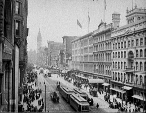
The pictures change around the turn of the 20th century, when mechanized vehicles start to take over the street. At this point pedestrians are being crowded out of their place and forced onto the sidewalks. The process may have been so gradual that hardly anyone noticed, but this seems to be what happened. The urbanists and architects of the early 20th century were right to denounce the congestion of the modern city. But what we see from the picture above is that the place occupied by vehicles is far less crowded than the space used by pedestrians. The crowding was purely artificial, the result of a process that no one may have been aware of.

The introduction of the automobile then made things even more unbearable, but at this point European and American cities took two opposite turns. While the streetcar moved at the leisurely pace of the horse-drawn coach, the automobile’s purpose was to go fast and cover distances that were beforehand too far. This could not be done in the congestion of the traditional street and required the production of an entirely new system of circulation, what later came to be called traffic engineering. American cities gleefully ripped up the streetcar tracks to make way for the new road system, literally driving place to the margins and choking main streets into economic starvation. In Europe the old tradition of place-preservation was applied and the new roads were only subtracted from place at a bare minimum, leaving about half of it left. That is how Boulevard Port-Royal remains so roomy for pedestrians, because there was no need to remove any more of it. And it is also why the design of Piccadilly Circus in London is so complex, balancing both traffic engineering and existing place improvements such as subway exits and fountains. By default, anything that doesn’t need to be traffic engineered is left to place.

london18

Even the problem of providing parking space can beautifully be solved by grouping parking into blocks surrounded by place. Here is a parking block in old Montreal. The dogma in parking planning has been that either the parking lot must be between the building and the road, such that customers and visitors will easily see how to park and won’t keep on driving right home, or the new dogma that parking lots must be hidden behind buildings because they are ugly and destroy urban space. Here however the parking is neither between the building and the street or behind the building, but across the street from the building. And it turns out to be unobtrusive, leaves plenty of open space to provide light and fresh air, and lets anyone walk right up to any building without having to cross a no man’s land of vehicle storage.

parking-block

In modern cities the process of place subtraction has been completely abolished. A modern urban development begins from a road and the road is extended through a parking lot to the entrance of the building. This was not the original modernist plan. Although the free-form street was supposed to be segregated into different pedestrian and automobile paths that would never intersect, the space set aside for pedestrians was gradually abandoned and removed entirely for various reasons, notably poor design and safety issues (as documented by Jane Jacobs). Place removed, all that remained of the modernist process of urbanization was the road hierarchy. Sprawl was born out of this mutation. Any available land that is not a building footprint is filled out with parking space or ornamental landscaping of fake nature. There is no land left over to place, although there is a sidewalk along the road.

Various movements to “reclaim the street” have sprung up in both Europe and America, sometimes going to zealous excesses (blocking Paris’ périphérique beltway). They have mostly focused their efforts in traditional urban centers, with the latest victories being the proposal to close off part of Times Square to yellow taxicabs and other vehicles. Top traffic engineers like the late Hans Monderman have figured out that traffic flow is best when it’s de-engineered, recreating place for better traffic flow at intersections. But what if we tried to reclaim place in suburban sprawl? What would it look like? Although buildings are huge, randomly situated and separated by wide gulfs of space, that really did not appear to be a problem in the pictures above of 19th century cities. Let’s try an experiment and assume that suburban sprawl has the same structure as a place-based city, then reintroduce road and parking lots within place, as was done in Europe.

The example I will use is the area of the Target store in Cupertino, California, just down the road from the headquarters of Apple Computers within the world’s richest sprawlopolis, Silicon Valley. I selected this site because the good people of Apple deserve to have a nice place to call home, and the biggest concentration of wealth in North America should have some kind of place to identify with.

target-sprawl

This is our starting point. I bet you think it’s hopeless. If I didn’t come in equipped with a process to create a place I would have walked away (driven away more likely). But from what we know of how place was formed in traditional cities it turns out to be really simple to build a place there. First we have to remove everything that isn’t a building and leave it as open space, the foundation for a place. Second, we draw a boundary around the buildings. Third, we reconnect the roads. Fourth, we add the parking blocks that the stores need to attract customers. And finally we spruce the place up with trees and other street furniture. The result doesn’t look that bad.

target-place

Without having to demolish any of the buildings we have made a place out of what was a tragic cluster of sprawl. At this point people are going to say that there probably isn’t enough parking, or the roads might not be sufficient to accommodate the traffic, but the great thing about a place subtraction process is that you always have some space in reserve to fix unforeseen problems. So instead of building parking spaces in strangulating numbers, you can just convert place to parking lots as they become necessary. If it turns out that the parking is just right, you can build more buildings there and turn it into a little downtown. Of course as you do so density increases and open space disappears. It’s a trade-off, but it’s one that we have deprived ourselves of by insisting in our planning codes that everything be done right at the start, which means that we have too much of everything and nothing left over for people. The biggest myth about sprawl is that it is low-density. In fact it is much too dense, every bit of space used for cars or buildings, which is why people are always complaining about wanting more open space.

French author Marc Augé launched the study of the non-place, ultimately describing it as a space where meeting others is impossible. Place, an emergent product of traditional urbanization, was always simply taken for granted. It has taken enormous intellectual effort, after a complete elimination of place, to understand what exactly was lost and how. It will take a reconstruction of cities just as massive and a paradigm shift in the practice of traffic engineering to restore it. Until then whenever I am in a modern city I will stay in the car. As much as I love walking in town, I am not going to lose my life for it.

Reference

The Geography of Nowhere by James Howard Kunstler, always a classic.

A video series of Hans Monderman showing his work creating places in “engineered, technocratic” new towns of Holland. And here is an introduction to shared space.

Related Posts

Squaring the circle

tultepec

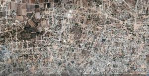
Natural paths of movement emerge through gaps in the blocks imposed by a municipal grid in the town of Tultepec, Mexico. These paths show how the street configuration of medieval cities comes to be defined. The urbanized gradient between the center of town and its outskirts shows the different stages in the emergence of a fully natural town.

For those with strong stomachs, scroll to the south to see some truly horrific modern housing blocks.

Slumdog Urbanist

A great article appeared in the NY Times about the setting for this year’s multiple academy-award winning film Slumdog Millionaire, which I recommend as an instant classic of urban filmmaking, the post-shantytown Dharavi.

Understanding such a place solely by the generic term “slum” ignores its complexity and dynamism. Dharavi’s messy appearance is nothing but an expression of intense social and economic processes at work. Most homes double as work spaces: when morning comes, mattresses are folded, and tens of thousands of units form a decentralized production network rivaling the most ruthless of Chinese sweatshops in efficiency. Mixed-use habitats have often shaped urban histories. Look at large parts of Tokyo. Its low-rise, high-density mixed-use cityscape and intricate street network have emerged through a similar Dharaviesque logic. The only difference is that people’s involvement in local development in Tokyo was seen as legitimate.

Building on what exists, rather than clearing it for redevelopment, may preserve not only the character of a place but also its economic vibrancy. In Dharavi, it would allow all residents to leverage their most precious asset: a place to live and work. Slum-rehabilitation projects in Mumbai often end up creating new slums elsewhere as they increase real-estate value in the places they redevelop.

In the movie, when the protagonists return to their childhood haunts, they find that multistoried apartments have replaced the old decrepit structures, giving the impression of urban mobility and transformation. What the camera doesn’t reveal are the enormous shantytowns hidden behind those glistening towers, waiting to be redeveloped all over again.

In many ways, Dharavi is the ultimate user-generated city. Each of its 80-plus neighborhoods has been incrementally developed by generations of residents updating their shelters and businesses according to needs and means. As Ramesh Misra, a lawyer and lifelong resident, puts it: “We have always improved Dharavi by ourselves. All we want is permission and support to keep doing it. Is that asking for too much?”

The film provides amazing cinematography of Mumbai, but what shocked me the most was the postmodern neoclassicist residential towers being built in the slum. They appear alien to the place, clashing with the natural, complex morphology of the neighborhood. That shows up in the google maps images also. It shows that employing modern building processes is a choice and not an inevitability, and it is a choice that can take away from the identity of a place. The people of Dharavi were insulted that their city was called a slum because they all had a hand in building it. They won’t be eager to defend the place when all its complex tissues have been replaced with tower blocks.

Chaos re-emerges

1960’s psychedelic art?

landscape-chaos

Or the American landscape?

Notice how much negative space is created by the imposition of the grid on a chaotic reality. The simplicity of the cartesian plan is deceptive. It generates complications as the random process of change unfolds.